Physical Map of China: Tibetan Plateau, Himalaya Mountains, Gobi and Taklamakan Deserts,
Yellow, Yangtze, Pearl Rivers
China's Geography and landscape is extremely varied, with a wide range of weather and climate as well.
Along the coast concentrate the main cities and ports.
In the North and West are mountains and deserts.
The South is crowded with jungles and tropical lowlands whereas the South-West is home to the harsher Tibetan Plateau.
The majority of the people live in the milder coastal areas and along the rivers. These areas are booming modern economic and industrial zones which are in high contrast to the poorer areas as you travel inland.
China Mountains and Plateaus

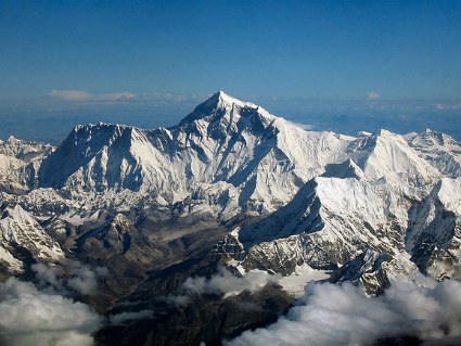
Himalaya Mountain Range and Mt. Everest
The Tibetan Plateau is the world's largest and highest plateau. It leads to the Himalaya mountains, which are at the China-Nepal border and are home to the highest peaks in the world, including Mount Everest, the highest at 8,850 meters or 29,029 ft above sea level.
The Tibetan Plateau, is also known as the "Roof of the World" and is home to the Autonomous Region of Tibet.
Because of the high altitudes and harsh cold temperatures in the winter that can drop to -40 F, these areas are some of the least populous in the world.
Southern China is also home to some extraordinary mountain scenery. The unusual formations and landscapes have inspired Chinese painters and artists since ancient times and these mountains are some of China's major tourist attractions. These are some of them:
China Rivers

The Yellow River Basin
Flowing out of the Tibetan Plateau are two of China's longest rivers, the Yangtze and the Yellow River. They cut accross China as they continue towards the coast through the more densely populated areas.
The Yangtze River is the longest in China and third in the world after the Nile and the Amazon. This is one of China's most important waterway and is the site of the Three Gorges Dam, the top producer of hydroelectricity in the world. To give you an idea, it has over 16 times the power generating capacity of the Hoover Dam.
The Yangtze River is also a major source of tourism for the area, Yangtze River cruises are quite popular for the jaw-dropping scenery of the Yangtze River Gorges.
The Yellow River is China's second longest, and it flows through the North China Plain, known as the cradle of ancient China, as this area was the most prosperous at the time, it is believed that the Chinese civilization originated in the Yellow River Basin.
The Pearl River, the third longest, is actually a system of several rivers and tributaries that share a common delta, the Pearl River Delta. The Pearl River Delta is famous for the special economic zones that have been set up along the estuary and are responsible for the rapid development of China's economy.
China Deserts

Taklamakan Desert
About 20% of China's land is desert land. The largest deserts in China are the Gobi Desert and the Taklamakan Desert, in the north-west of the country where sand dunes and rocky landscape extends in all directions for as long as you can see.
These areas are sparsely populated due to their arid environment and harsh winter climate.
More China Facts
filling each day with peak of health...
abundance of happiness...
bountiful prosperity...
and Zen like serenity...
Most Popular Excursions
Book with confidence! Free cancellation: Cancel up to 24 hours in advance to receive a full refund


Got a tip?
Got something to share? Let us know!